Ask Professor Puzzler
Do you have a question you would like to ask Professor Puzzler? Click here to ask your question!
In a previous post, Kathryn from Florida wanted help figuring out how long her house would be under Hurricane Irma. I gave her a rough formula to use, with the strong disclaimer that this was approximate, and should not be used as a means for determining any course of action. The formula turned out to be a reasonable guideline, and for the few days leading up to the hurricane's passage, that blog post became one of the most popular pages on The Problem Site. I'm glad I was able to provide useful information to so many people.
The formula, which you can find developed here: Hurricane Passage Approximation Formula, is T = 2SQR(R2 - D2)/V, where:
- R is the radius of the hurricane
- D is the distance of the closest passage of the eye to your home
- V is the velocity
- T is the time you can expect to be under the storm
The formula required you to take a "snapshot" of the hurricane at a given moment, and make the assumption that the hurricane's size, shape, speed, and direction remain unaltered during its journey up the coast. None of these assumptions are perfect, of course, and some were "less perfect" than others.
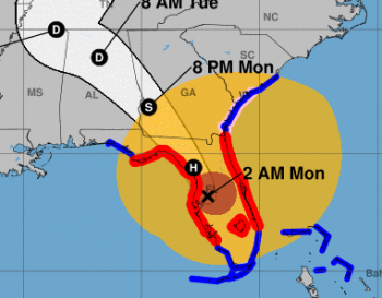
If you watched the hurricane passing up the coast of Florida on weather maps, you could see very clearly some of the reasons that this formula should only be used as a rough approximation. Most of the reasons can be summarized by this screenshot of a National Weather Service hurricane map (click it for a larger version). The red circle represents the region that is currently under hurricane force winds (at least 74 mph sustained winds). The larger circle represents tropical storm force winds (between 39 and 73 mph winds). This image was captured at 8:00 Monday morning. The map was updated every three hours for the duration of the storm.
Here are some of the noteworthy ideas that this image (and others in the sequence of updates) shows us:
- The formula given makes the assumption that the storm is circular. Irma was roughly circular for most of its lifespan, but as it worked its way up the coast of Florida's peninsula, it became much more elliptical in shape, stretching out wider and wider. Since the storm was wider east-to-west than north-to-south, and it was traveling in a roughly northerly direction, if you were using its widest extents as your R, the storm's passage would have been shorter than the formula predicted.
- In addition, although the eye was fairly central to the storm during much of its passage through the Caribbean, before it made landfall in Florida, the storm's internal structure had changed significantly; the tropical storm force winds had shifted to being largely to the north east of the eye. You can clearly see this change in the image; the X and the red portion of the hurricane are far to the west and south of what we would call the "center" of the storm. Thus, if you used the closest approach to the eye as your D (distance), you're using the wrong point. To be more accurate, the formula would require you to know the approach angle of the storm, as well as the extents (we'd call it the "diameter" if it was circular) of the storm perpendicular to the approach angle. This information would be used to more accurately pinpoint a "center." Of course, the more information you have to collect to use the formula, the less likely it is that you'll be able to use it. As it stands, someone on the east coast of Florida who used that formula will probably find that they were under the storm for longer than the formula suggests, while someone directly under the eye would find that the storm didn't last as long as the formula suggests.
- By comparing this image to others I saw through the passage of the storm, it's clear that the storm was continually changing in size. In this image, by doing some rough line-drawing and measuring on Google Earth, I was able to estimate the maximum extents of the tropical storm winds at about 575 miles, which is significantly different from what it was when it reached Kathryn's city. Three hours later, it was about 50 miles wider at its widest point. We knew this would happen, of course, but I confess that, as someone who is not a meteorologist, I didn't expect the storm's size to change as quickly and as significantly as it did. Even so, there isn't any good way to work this possibility into a simple formula. When the time under the storm is more than 24 hours, that's a lot of time for the hurricane's structure to change.
- Similarly, the speed of the hurricane has also been changing during the passage up the coast, though this was by far the least significant of the changes; my recollection is that the storm's speed only fluctuated by ±3 mph.
- Another thing which could have happened (but didn't) - the storm could have done a drastic change in direction. Imagine you were almost all the way through the storm, and suddenly it shifted direction (the way Jose is doing out at sea right now), and backtracked over you. You'd be in the storm much longer than the formula could predict.
All of these points contribute to the emphasis that this formula is a very rough approximation. Of course, nobody was looking for an exact prediction - people were more interested in knowing whether they'd be under the storm for a few hours, a few minutes, or a few days. For all its simplistic faults, the formula gave an excellent guideline for anyone living on the Florida peninsula.
The hurricane could have been far worse than it was; every time the hurricane came in contact with land, it lost energy, and any time it wasn't in contact with land, it started revving up again*. A much more destructive course would have been: the hurricane passes by Cuba just a few miles further north, and then passes up west of the Florida peninsula, to make landfall around Tampa. As it was, Irma churned up a lot of energy in Cuba - dropping from Cat 5 to Cat 3 as it devastated that island, and then continuing to expend its wrath on the less-populous Monroe and Collier counties before reaching Tampa as a Cat 1 hurricane. It's easy to forget (but should not be forgotten) that Tampa's "good fortune" in this regard comes at the cost of life, property, and livelihood of people further south, both in and out of the United States.
* Keep an eye on Hurricane Jose, which (as of 5:00 AM, Sept 12) is just churning in circles in the Atlantic. It's currently very small, and predicted to drop below hurricane level shortly. But as it continues to wheel about over the sea, it is predicted to regain hurricane status before heading back in the general direction of the Carolinas.


